Holiday Travel Forecast: Major Christmas Eve Winter Storm to Impact Millions in Midwest, East
By Alex Sosnowski, Expert Senior Meteorologist
December 19, 2014; 10:47 AM ET
Update at 1:00 p.m. EST Friday, Dec. 19, 2014:
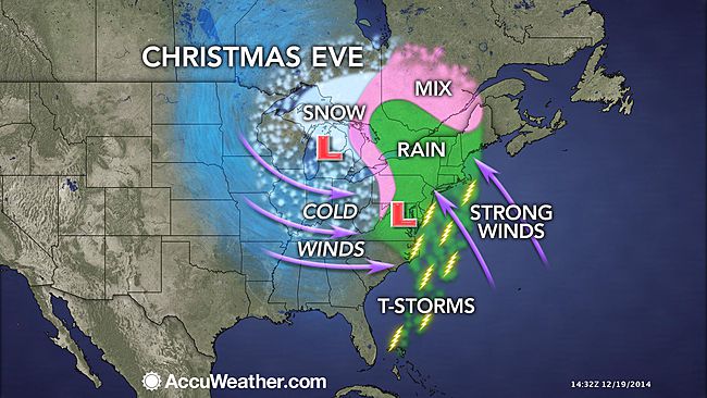
A major storm centered on Christmas Eve will affect the Midwest and East with areas of strong winds, heavy snow, torrential rain and thunderstorms.
A storm forecast to develop over the lower Mississippi Valley on Tuesday, Dec. 23, is likely to strengthen dramatically, while it races northeastward toward the eastern Great Lakes on Christmas Eve.
The most far-reaching impact from the storm will be strong winds that develop and that have the potential to cause substantial flight delays along the Interstate-95 corridor, parts of the South and the Midwest. Turbulence could be an issue for some flights.
Those with direct or connecting flights to New York City, Boston, Philadelphia, Baltimore, Washington, D.C., Atlanta, Cincinnati, Detroit and Chicago should be prepared for disruptions and delays due primarily to wind, but also rain, thunderstorms and in some cases snow.
Ripple-effect delays are possible elsewhere across the nation if aircraft and crews are displaced due to the weather in the Central and Eastern states.
Travel by ground may be challenging to dangerous at times for motorists, due to poor visibility in rain, urban flooding and wind in some areas, and due to snow, wind and slippery roads in others.
According to Northeast Weather Expert Dave Dombek, “The current anticipated track of the storm will lead to primarily a rain event on the Atlantic coast and in much of the Appalachians.”
A period of windswept rain will swing northeastward spanning Tuesday night through Wednesday night in the East. The worst of the wind and rain on the front-side of the storm may be from Philadelphia to New England.
“Fog may be a problem in parts of the Northeast, due to warmer air moving in on cold ground and snow cover in some locations,” Dombek said.
A storm forecast to be as dynamic as this is likely to produce thunderstorms.
According to Severe Weather Expert Henry Margusity, “A storm that becomes as strong as we suspect could produce severe thunderstorms from the eastern part of the Carolinas to Delmarva.”
Thunderstorms could extend as far north as southern New England and as far south as Florida.
Snow during part of the storm is likely in the Upper Midwest. This includes the cities of Chicago, Detroit and Indianapolis.
While it is too early to say where the heaviest snow will fall, there is the potential for a sudden burst of snow and a quick freeze-up to occur in the swath from Wisconsin and Illinois to Indiana, Ohio, western Pennsylvania, Kentucky and Michigan.
Snow could reach as far south as Tennessee, since colder air will wrap around the storm, before dry air sweeps precipitation away.
According to AccuWeather Expert Senior Meteorologist Dan Kottlowski, “Impact from adverse weather conditions from the storm will not stop on Christmas Eve.”
As the colder air sweeps into the Appalachians from south to north spanning Christmas Eve night through Christmas Day, there is a similar chance of a period of accumulating snow behind the storm.
Depending on how much the storm intensifies, gusty winds, with and without snow, will continue and may increase and become very strong over the Midwest on Christmas Day.

Gusty winds from the west will buffet areas of the Atlantic Seaboard in the absence of snow on Christmas Day as well. The winds will blast colder air into the region.
The best advice for travelers at this time around the Christmas holiday is to consider leaving for your destination before the worst of the storm hits, such as Monday into Tuesday.

There is a risk of getting stuck on the road or at an airport terminal especially in the Midwest and Northeast on Christmas Eve into Christmas Day.
Travel conditions will improve over much of the area from south to north spanning later Christmas Day and Friday.
As more details become available on the track, speed and strength of the storm near Christmas 2014, we will provide updates on AccuWeather.com.
A shift in storm track farther east or west will determine which areas in the Midwest will be hit with mostly rain versus mostly snow. The speed of the storm will also affect which days are the best and worst for travel next week.
Meanwhile, as a storm affects a heavily-populated area of the Central and Eastern states around Christmas, a different storm will affect part of the West with areas of heavy rain and snow.
More details on which highways and airports in the Great Basin and Rockies will be hit the hardest with snow for Christmas Eve and Christmas day will be released as they become available.

