Blizzard of 2015 to Shut Down NYC, Boston Tuesday
By Brian Lada, Meteorologist
January 26, 2015; 3:53 PM ET
Flight cancellations are mounting and travel bans and state of emergencies are being issued ahead of the major blizzard that will halt travel, cut power and endanger anyone who ventures out into the storm.
The clipper that brought snow to the mid-Atlantic on Monday will explode into a monster snowstorm and blizzard Monday night through Tuesday.
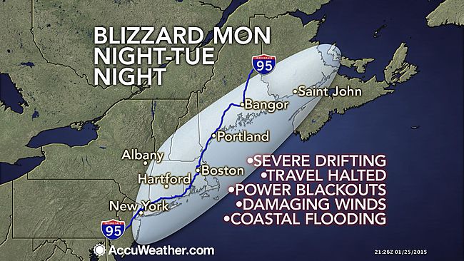
The heavily populated zone from New York City to Boston to Portland, Maine, will be brought to a standstill with impacts lingering well after the blizzard departs.
Once the system reaches the waters off the Northeast and turns northward, it will rapidly intensify Monday night and cause a major snowstorm to unfold around Philadelphia with the blizzard developing from central New Jersey to New England through Tuesday.
Conditions will worsen around New York City through Monday night as travel rapidly deteriorates northward to Boston, then from Portland to Bangor, Maine, to Saint John, Canada, Tuesday. Travel will become impossible during the height of the storm.

Conditions will improve in a south-to-north fashion Tuesday night through Wednesday as the storm bears down on Atlantic Canada.
This could turn out to be the biggest storm of the winter for many areas in the Northeast and could rank among the greatest snowstorms in some communities (See a List of New York City’s Historic Snowstorms).
Snow totals will reach or exceed 2 feet across a large part of Long Island and southern New England. This includes Manchester, New Hampshire; the Boston area, Worcester and Springfield, Massachusetts; Hartford and New Haven, Connecticut; Providence, Rhode Island; and Islip, New York.
Between 1 and 2 feet of snow is forecast to fall in New York City; New Bedford, Massachusetts; Concord and Portsmouth, New Hampshire; and Portland, Augusta and Bangor, Maine.

During the height of the storm, snowfall rates in the New York City area and southern New England could reach 4 inches per hour. It is during these extremely heavy snow bands that thunder could be heard.
Strong winds howling during the storm will cause severe blowing and drifting of the snow. Drifts in the I-95 corridor may average 5 to 8 feet from New York City northward. Drifts could even approach 10 feet toward Boston. Roofs may fail under the weight of such drifts.
People using shovels to clear the snow should take their time and take frequent breaks while shoveling to reduce the risk of heart-related injuries and fatalities.
Impacts from the powerful storm will be felt all across the Northeast and into portions of Canada, but the worst of the storm is expected to focus on the area from New York City to Boston to Portland, Maine.
The blizzard will unload heavy snow and winds howling past 35 mph. The combination of the snow and wind will dramatically lower visibility down to zero. Winds in southeastern Massachusetts can occasionally gust up to near hurricane force during the worst of the storm Tuesday morning.

Travel conditions will quickly deteriorate across the area as the heavy and wind-swept snow moves in. As the storm worsens and reaches its peak, travel will be halted.
Motorists traveling at the height of the storm run the risk of becoming stranded as roads rapidly become clogged and snow-packed and the dangerously low visibility.
“Anyone stranded will face life-threatening conditions unless they have an emergency survival kit. Rescuers may not be able to reach them,” stated AccuWeather.com Chief Meteorologist Elliot Abrams.
“Surface transit may be suspended as well,” Abrams added.

Adding to the mounting flight cancellations, there is a high chance for airports to close for a time on Tuesday from New York City northward.
Travel delays associated with this storm will not be limited to the Northeast.
Ripple-effect delays are possible elsewhere in the nation if airplanes and crews are displaced due to the storm.
Lengthy power outages may result due to the strong winds, especially closer to the coast. The winds could also cause tree damage, which would pose additional hazards to those attempting to navigate snow-covered roads and sidewalks.

These strong winds blowing off the ocean can cause coastal flooding and beach erosion from New Jersey northward with the worst flooding occurring from late on Monday night into Tuesday evening.
“Luckily for area residents, Monday marks the first quarter of the solar cycle (half the moon is visible). This means that the difference between high and low tide will be minimal,” stated AccuWeather.com Meteorologist Evan Duffey.
“Also, Jan. 21 was Perigee when the moon was closest to the Earth. If the storm had come five days earlier, the high tide would have been higher by a good margin. The combination of these factors will work against the storm somewhat to limit coastal flooding.”
Conditions will improve by Wednesday as the blizzard departs, allowing crews to begin the cleanup process in the wake of the storm.
Even after the worst of the storm has passed, it could take days for power to be restored, air traffic to return to normal, roads to be fully geared and schools to get back in session.
“Lingering midwinter cold and additional rounds of snow will add to difficulties for cleanup and those without power after the Blizzard of 2015,” stated AccuWeather.com Senior Meteorologist Alex Sosnowski.
The economical impact of the blizzard will also be fully assessed after the fact. While companies could suffer losses, the blizzard could actually benefit others.
For example, companies will be faced with extra expenses due to transit being shut down, power outages and goods not being able to be transferred. On the other hand, the blizzard will eventually be a boost for the ski industry and stores that sell generators or other storm-related supplies.
AccuWeather.com Senior Meteorologist Kristina Pydynowski contributed to the content of this story.

